Data Provider Toolkit
Learn how to submit data to Dandjoo.
Becoming a data provider
Who can submit data to Dandjoo?
BIO welcomes submissions from all organisations and individuals with expertise in biodiversity data collection.
We anticipate that the majority of our data providers will be:
- State and Federal government agencies
- Local governments
- Private industry (e.g. resources and energy companies, environmental consultants, and developers)
- Universities and other research organisations
- Biodiversity collections managers (e.g. museums and herbaria)
- Not-for-profit organisations involved in conservation work
If you are not in one of these categories but do have high-quality data to contribute, please contact us. Our curatorial staff will be happy to discuss your data and assess whether it will be suitable for ingestion. However, do note that we are unable to accept one-off, individual sightings from members of the public at this time - if you have citizen science data to share, consider submitting it to a community platform such as iNaturalist or eBird.
What types of data does Dandjoo accept?
BIO currently accepts species observation data, systematic survey data, and vegetation association data. For more information on these data types, see the ‘Preparing your data for submission’ section of this toolkit. Our initial focus is on medium-to-large datasets, but also welcome smaller data sets that are of high quality.
How do I register as a Data Submitter?
You must register for a Data Submitter account to provide data to Dandjoo. Registering allows BIO to tag future submissions from the same provider, and ensure your data custodianship is recognised. It also allows our curators to provide you with data quality feedback, and contact you with any questions about your submission.
To register for a Data Submitter account, please follow these steps:
- Visit the Contact Us page on the BIO website.
- Select “Account request” in the Topic dropdown.
- Fill out the following fields:
- Name
- Organisation
- Job title
- Telephone
- Add a comment to let us know why you would like to register.
- Click ‘Send Message’ to submit your application.
Your request will be received by BIO and processed as quickly as possible. Our curatorial team will contact you if BIO has any further questions about your registration.
How do I log in?
Once BIO has approved your registration request, you will receive an email with your username (the email address provided in your application) and a temporary password. To log in, follow these steps:
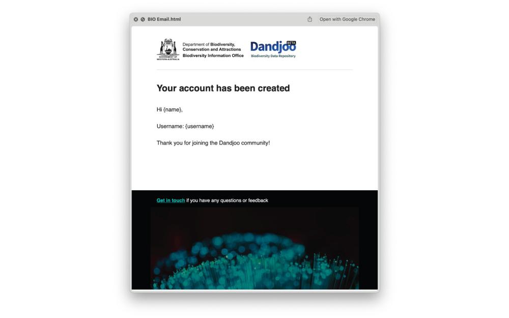
- Log in to your email account and check that you have received an email from us (BIO@dbca.wa.gov.au) confirming that your account has been created:
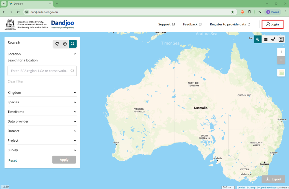
- Visit the Dandjoo homepage and click on ‘Login’ in the top left corner:
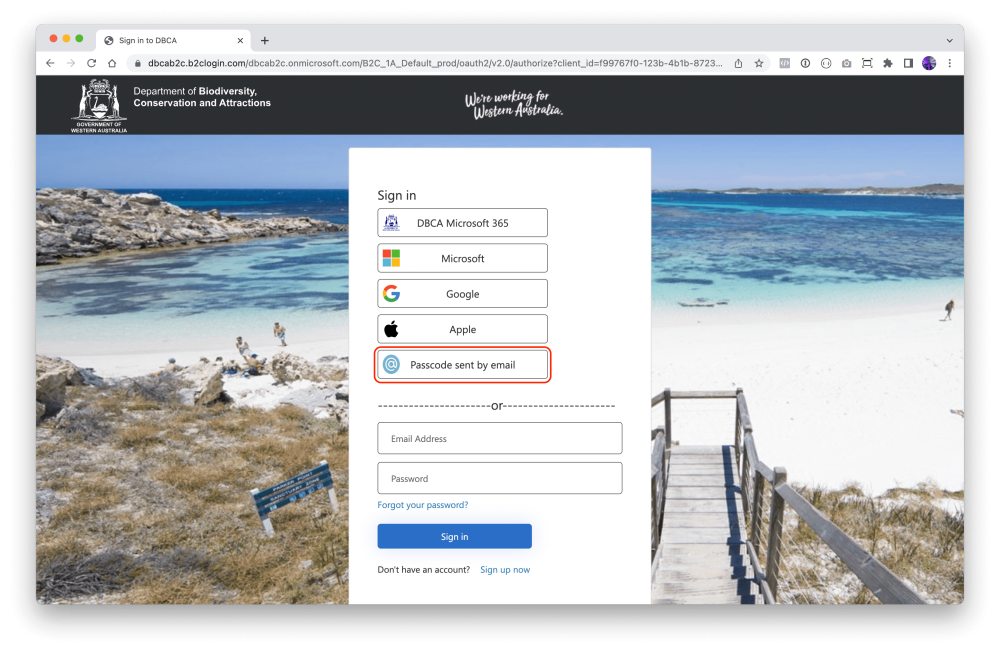
- You will then be forwarded to the Department of Biodiversity, Conservation and Attractions sign-in page.
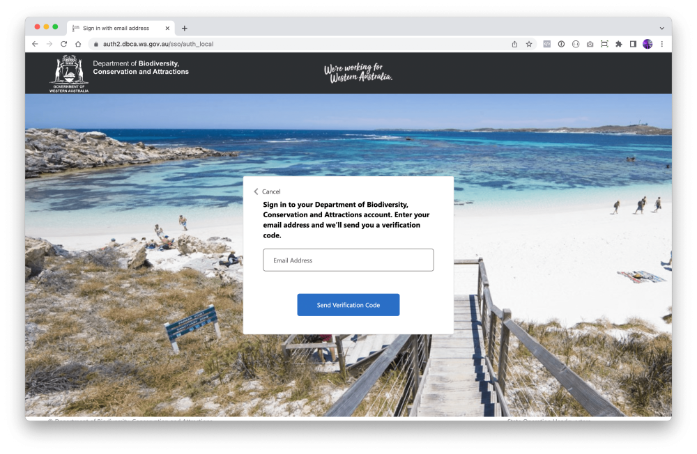
- Choose the option “Passcode sent by email”:
- Type in your email address and click ‘Submit’.
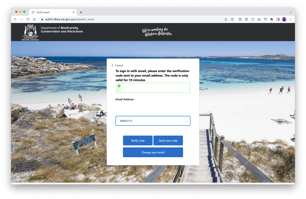
- Check your inbox for an email from the Department of Biodiversity, Conservation and Attractions (noreply@dbca.wa.gov.au) with your session passcode.
- Copy and paste the session code into the verification dialog that has opened in your browser, then click ‘Verify Code’:
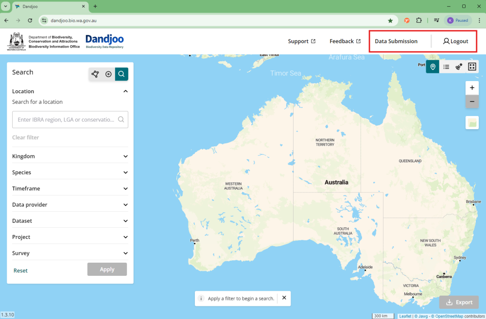
- Once verified, you will be redirected to the Dandjoo home page. You can now access the Data Submission portal:
The data lifecycle
1. Prepare data
The data lifecycle begins with preparing your data for publishing by ensuring that it meets the technical requirements for being published on Dandjoo (e.g. using standard file formats, ensuring it fits within platform limits). You can read more about preparing your data below.
2. Prepare supporting material
Once data preparation is complete, the next key step is preparing supporting material to be published with your data to enable people to understand it. You will be asked what geographic coordinate system, map projection or datum your data uses during the submission process.
3. Upload and curate
With your key preparation steps completed, you can now log in and submit your data. If you run into difficulties submitting, our staff can assist with the process. We may also contact you during the curation process to ask how you would like us to treat any records with potential taxonomic, temporal, or spatial errors.
4. Make it discoverable
When curation is complete, we’ll publish it for you on Dandjoo. Congratulations!
5. Ongoing maintenance
With your dataset now published and discoverable, you’re at the last key step in the data lifecycle - ensuring processes are in place for the ongoing maintenance of the data. For once-off datasets, we’ll perform routine maintenance of taxonomic names and conservation codes. If your data changes often, speak to us about establishing a data refresh process.
Preparing your data for submission
Dandjoo currently accepts data in .csv, .xlsx, .xlsm or .shp formats with file sizes of up to 500MB. If you have data to submit that does not meet these requirements, please contact BIO, and one of our technical staff will be in touch to discuss how best we can ingest your data.
Dandjoo does not require you to provide your data in a template. However, if you have data in a spreadsheet with multiple worksheets, note that Dandjoo will only read the first worksheet in your file. If you want to submit data from other worksheets, you can either:
- aggregate your data on a single worksheet prior to submitting, if your column headers are consistent across all worksheets; or
- save each worksheet as a separate document, and submit them individually.
Dandjoo ingests data in various ways, depending on how the data was collected. Currently, it accepts three data types; species occurrence data, systematic survey data, and vegetation association data.
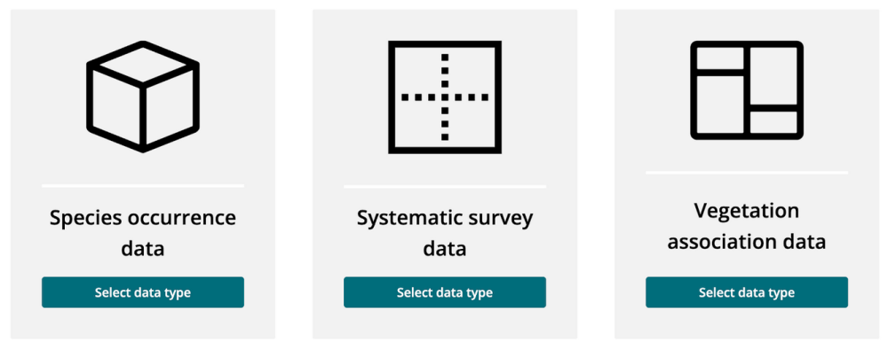
- Species Occurrence Data: Information about where a species was observed. Your dataset will contain a list of records by species, with information about the date and place each was observed. Each record in the dataset may refer to one individual of the species, or may include a count to indicate how many of the species were observed. The dataset may be generated from a systematic survey of sites, but the data will be arranged by species name.
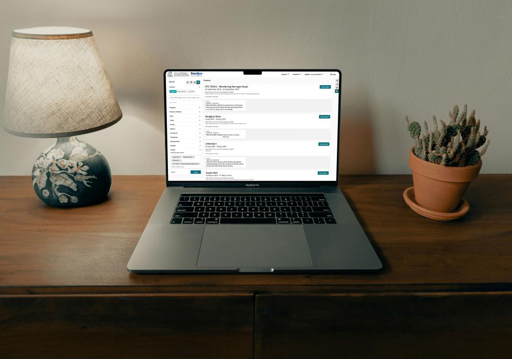
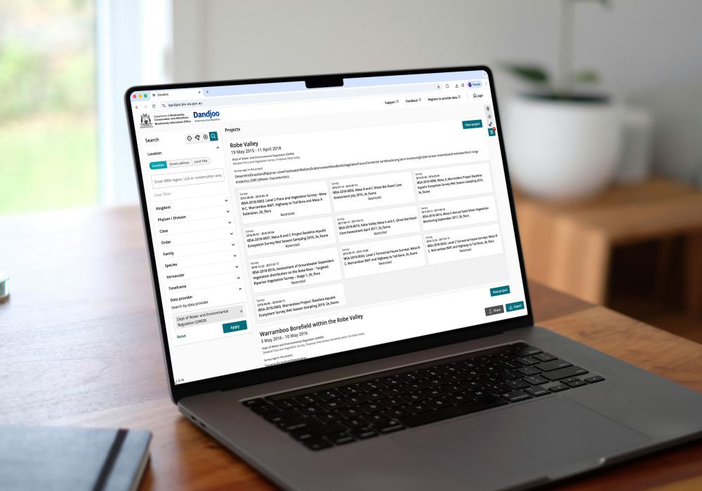
- Systematic Survey Data: Information about observations of multiple species in a systematic survey. Your systematic survey data will contain one overarching project with one or more surveys, with each survey having one or more record of species observed.
- Vegetation Association Data: Information about vegetation associations. Your dataset will contain the polygons that define the boundaries of the vegetation associations.
Submitting species occurrence data
Submission requirements
Our submission tools include a quality assurance routine to validate the structure of species observation data files.
Please read the requirements below and check your file beforehand to ensure a quick and easy submission process.
- .csv, .xlsx, and .xlsm files are arranged in rows and columns, with the top row containing headers.
- The file contains an event date field.
- The file contains either latitude/longitude fields or eastings/northings/zone fields.
- The file contains a field or fields that identifies the organism (this should, at a minimum, provide genus and species; components of the organism’s scientific name may be in one field, or split across several fields).
- .shp files are zipped and include a.shp, .shx, and a .dbf.
- Column headers / field names are unique.
- Column headers / field names cannot be just a number. For instance, a column header of ‘1’ will not be accepted, but ‘one’ or ‘_1_’ will be.
- For .xlsx and .xlsm files, all data is contained on the first worksheet (additional worksheets will not be processed).
- Mandatory fields are populated for every record in the file, although it is acceptable to have blank cells in optional fields.
- Mandatory date and location fields contain an expected data type (Dandjoo recognises most common date formats and coordinate formats).
- The file contains at least one record (files that are blank other than a column headers will not be processed).
- The file does not contain special characters (files may only contain UTF-8 encoded characters).
If you attempt to upload a file that does not meet these requirements, you’ll receive a warning message.
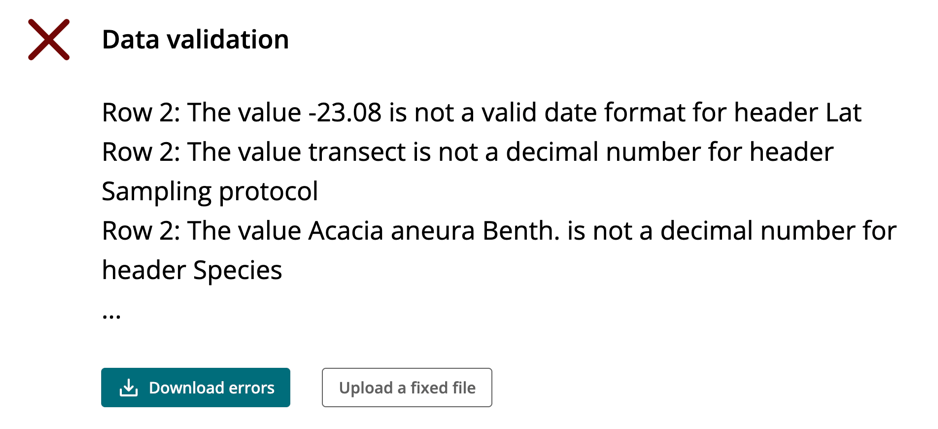
If you have difficulty in submitting your data as a result of the submission requirements, please contact BIO for support, and to let us know how the submission process can be improved in the future.
Mapping your data to a standard
You can use our self-service tools to ‘map’ species occurrence data to a selection of standard Darwin Core fields.
Resources
During submission, you will be asked to match headers of your submitted data to certain fields (for instance, ‘scientific name’ or ‘event date’). These fields are derived from internationally-recognised standards for biodiversity data and help us manage your data in a way that is consistent with FAIR data principles (Findable, Accessible, Interoperable and Reusable).
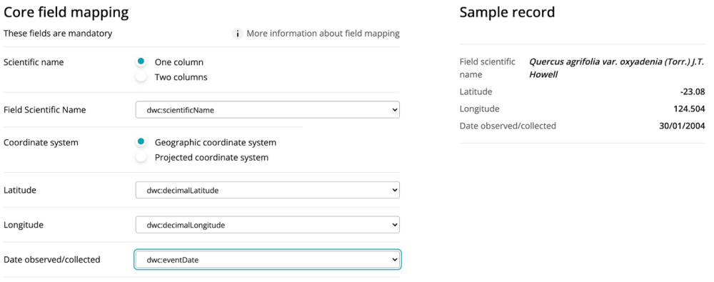
Some fields are mandatory - for example, we need to know the ‘what’, ‘when’ and ‘where’ of an observation to display it meaningfully. However we also offer submitters the opportunity to map data against a variety of optional fields derived from multiple international data standards (eg. Darwin Core). Mapping optional fields greatly enhances the value of your data for other users - for example, if you map the ‘habitat’ field to one of your variables your data can be combined and analysed with other datasets that also contain the same field. We highly encourage submitters to map optional fields, as it will help others understand and interpret the data.
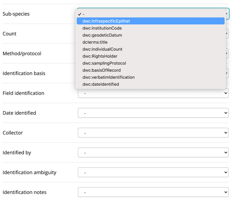
We believe that submitters are best placed to map their data, as they generally understand it best and are familiar with how it was collected. However, if you’re having difficulty mapping your data, don’t hesitate to ask us for help. BIO’s curatorial staff are familiar with data standard and the way in which other datasets have been mapped, and can assist you with submission and mapping.
Submitting systematic survey data and vegetation association data
If you submit systematic survey or vegetation association data, you will skip the self-service mapping stage, but the submission process is otherwise the same. BIO is exploring options to provide a mapping service for these data types in future releases, in addition to enhancing the way in which they are displayed for data users.
What happens to data after it is submitted?
When you submit your data you will receive a unique submission ID. We recommend that you record this ID so that it can be used as a reference if needed.
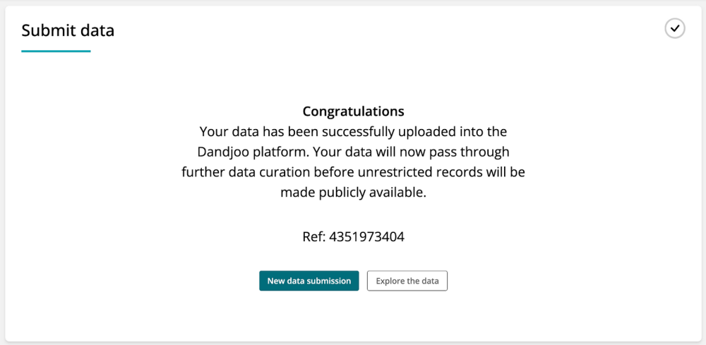
BIO will also preserve a copy of your original submission in long-term storage, attached to your submission number. This copy provides a record of the data as it was originally provided, and will be retained for archival purposes and to ensure that the provenance of records in Dandjoo is auditable.
Your submission will then pass through to the curation stage. You can learn more about BIO’s curation processes on our Data curation page. If our curatorial team identifies records with apparent errors during curation BIO will contact you for your input - for instance, you may approve a change to a record (such as correction of an obvious spelling error) or may ask for the record to be archived.
After curation, your data will be published on Dandjoo and become available to the public (with the exception of threatened and priority species records, which will be restricted). You may contact BIO at any point to request records be corrected or archived in Dandjoo in the future, but they will otherwise remain visible to users.
Resources:
As part of the State-Commonwealth Digital Environment Assessment Program, mapped fields in data submitted to Dandjoo are also transmitted to the national Biodiversity Data Repository on publication. This is part of BIO’s broader commitment to make Australian biodiversity data more shareable, accessible, and openly available.
Data provider tips
- Publish responsibly: Take care to publish data safely. Be mindful of privacy, copyright, intellectual property, commercial-in-confidence, and security issues that may relate to your data. Clean fields to remove phone numbers and email addresses that you may not want to share. If you’re not sure about whether you should redact information or whether you’re allowed to submit data, don’t submit it - talk to us first!
- Understand how submission works: Read our Preparing your data for submission section and make sure you’ve reviewed the submission requirements for an easy submission experience.
- Describe your data well: Provide meaningful metadata, and map as many optional fields as possible to enhance the usability of your data. If there’s anything that you’d like to highlight about your data, you can use the comments field during submission to tell us more.
- Keep your data up to date: If you want to submit a dataset that’s routinely refreshed, contact us about setting up a refresh process.
Guidelines, services and standards
BIO Blog
We have added functionality to be able to search, view and download (where available) Systematic Survey Data in the Dandjoo platform.
Join the BIO newsletter and get updated first
Sign up for access to the latest developments at the Biodiversity Information Office, upcoming Dandjoo features, and our newest datasets.